Page 4 - Demo
P. 4
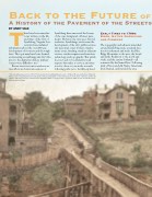
Back to the Future of
A History of the Pavement of the Streets
BTY ANDY SALE
here have been many his-
tories written on the life and times of the City of Lynchburg, Virginia, but very few have included
information about the over 200-year development of its streets and thorough- fares. The topic may have been deemed as interesting as watching paint dry! Also, prior to the digital revolution, primary sources were difficult to use.*
Recent street renovation and restora- tion efforts in downtown sections of
Lynchburg have uncovered the beauty of the once denigrated old street pave- ments. However, the story goes beyond aesthetics. Lynchburg’s streets trace the development of the city’s public services, city personnel, street workers, mainte- nance issues, funding, trends in adjacent services, resident requests and reactions, technology, and topography. This article does not seek to be exhaustive in all respects but rather to serve as an invita- tion for others to join in the research, following paths yet to be fully explored.
Early Times to 1700s:
Bison, Native Americans, and Pioneers
The topography and adjacent watershed around Lynchburg create a natural loca- tion for settlement and trade: the Blue Ridge Mountains to the west, the broad and fertile Piedmont to the north and south, and the eastern lowlands—all connected by the James River. Following trails of bison and elk, Native Americans lived, hunted, and traveled the area
* The city’s annual reports from 1859-1935, housed in the Lynchburg Museum at the Old Court House and the Jones Memorial Library, serve as the primary basis for this article, with special emphasis on the written reports of the street committee and the city engineer. They have now been scanned and are digitally available on compact discs. Quotations which are not cited in this article are from this new source.
LYNCH’S FERRY