Page 5 - Demo
P. 5
Lynchburg Streets
of Lynchburg, Virginia
around what was to become the City
of Lynchburg. The Monacan village of Rassawek, near the confluence of the James and Rivanna rivers, had trails lead- ing south “to a shallow place in the river, where buffalo crossed.”1 This crossing point on the James River became a meet- ing and trading place for Monacans, and also served as a gathering spot for early pioneers heading west.
Old maps refer to the shallow crossing as “Horse Ford.” To reach it, eighteenth- century travelers came down a ravine
from the Amherst County side of the river, crossed the James at the western point of Percival’s Island, and climbed the southern bank up the watershed of what came to be known as Horseford Branch. This southern access led natu- rally to the Wilderness Road via the New London, Salem, and Lexington turn- pikes, as well as to trails heading south into North Carolina.
Tracing the footsteps of bison, Native Americans, and early pioneers, it appears that Lynchburg’s present Horseford Road
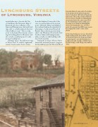
Horseford Branch runs under the bridge in the photo at left, which shows the state of streets in 1870 when this photo was made. This is the section of Church Street between Twelfth and Washington streets just before the ravine was filled in. The footbridge, built in 1856, gave the only access between Washington Street and downtown. As a reference point, the present-day YMCA now covers the empty field at the center of the photo.
In the map below you can see Horseford Road leading to the ford, which crossed at Percival’s Island. The map was drawn by John Lynch Jr. to help his father in a petition to build a bridge at Ninth Street. His first bridge, a toll bridge, was built in 1812.
FALL/WINTER 2010